KOMPSAT-EOC SENSOR MODEL ANALYSISKiin BANG and Prof. Woosug CHO, KoreaKey words: KOMPSAT, Sensor Model, Collinearity Equation. AbstractIn recent years, many countries have been giving special interest on space program, especially multipurpose high resolution and hyperspectral satellite. As one of national space programs in Korea, the first Multi-Purpose Satellite 1 (KOMPSAT-1) was launched on December 1999 and carried out its own mission. The EOC (Electro-Optical Camera) is the primary payload for KOMPSAT-1. The main mission of EOC is to provide the stereo images for the production of topographic maps of Korean territory. An essential element in capturing geospatial information through satellite imagery is to establish accurate sensor model. There have been so many researches on satellite camera model. In general, camera model for satellite imagery could be categorized into three groups: physical, semi-physical and mathematical models. The semi-physical model could be collinearity model or extended collinearity model. In this study, we developed ten different sensor models for KOMPSAT-EOC and applied to stereopair for analyzing their behaviors. The satellite sensor models, which were extended from collinearity condition equations, were developed and then the behavior of each sensor model was investigated. The satellite sensor models were represented by the six exterior orientation parameters in 1st, 2nd and 3rd order function of satellite image scanline. Among them, the rotational angle parameters such as w(omega) and f(phi) correlated highly with positional parameters could be assigned to constant values. For the experiments, two different stereopairs of KOMPSAT-EOC satellite images exposed to the similar area in different pass were used. 1. INTRODUCTIONGeographic Information System (GIS) enables the integration of diverse types of natural and man-made features such as mountain, river, road and building, and corresponding nonspatial attribute data. In this context, National Geographic Information System (NGIS) which makes possible the consistency and standardization of various geographic data and avoidance of overlapped investment for implementation, is recognized as one of the most fundamental infrastructures planned and developed by central government in Korea. At the end of the 20th century, the advanced nations have already applied GIS to various fields such as urban management, disaster and facility management, and environmental management. In the same context, Korean Government has initiated a full-scale implementation of NGIS master plan in 1995. The NGIS master plan can be categorized mainly into the generation of spatial database for national geospatial framework data, establishment of data standardization, assistance of GIS-related technical improvement and development of infrastructure for utilization and application of NGIS. Under the scope of NGIS, the GIS data compilation work in various sectors is successfully making headway. In addition, Korean government supports Korea Space Program where Korea Aerospace Research Institute (KARI) has developed KOMPSAT-1 that was launched on December 1999. The EOC (Electro-Optical Camera) is the primary payload for KOMPSAT-1. The main mission of EOC is to provide the stereo images for the production of topographic maps of Korean territory. An essential element in capturing geospatial information through satellite imagery is to establish accurate sensor model. There have been so many researches on satellite camera model. In general, camera model for satellite imagery could be categorized into three groups: physical, semi-physical and mathematical models. The semi-physical model could be collinearity model or extended collinearity model. In this study, we developed ten different sensor models for KOMPSAT-EOC and applied to stereopair for analyzing their behaviors. The satellite sensor models extended from collinearity condition equations were developed and then the behavior of each sensor model was investigated. The satellite sensor models were represented by the six exterior orientation parameters in 1st, 2nd and 3rd order function of satellite image scanline. Among them, the rotational angle parameters such as ω (omega) and Φ (phi) correlated highly with positional parameters could be assigned to constant values. For the experiments, two different stereopairs of KOMPSAT-EOC satellite images exposed to the similar area in different passes were used. 2. KOREA MULTI-PURPOSE SATELLITE 1 (KOMPSAT-1)Under Korea National Space Program, Korea Aerospace Research Institute (KARI) has developed and launched KOMPSAT-1 in December 1999. The KOMPSAT-1 satellite is a small satellite with the mass of 500kg to be operated at the sunsynchronous orbit which has 98 minutes orbit period, 28 days repeating ground track, 10:50 AM ascending orbit crossing time, and 98.13 degrees inclination at the altitude of 685km. The lifetime of KOMASAT-1 is expected to be over 3 years. KOMPSAT-1 includes three instruments such as Electro-Optical Camera (EOC), Ocean Scanning Multispectral Imager (OSMI), and Space Physics Sensor (SPS) for the mission of cartography, worldwide ocean observation, and space environmental monitoring, respectively (Paik 1998). 2.1 Electro-optical Camera (EOC)Figure 1 shows the EOC operational concept of image collection. The primary mission of EOC is to provide images for the production of cartographic maps and digital elevation models of the Korea peninsula. EOC collects panchromatic images with the ground sample distance (GSD) of 6.6m and the swath width of 17km at nadir through the visible band of 510~730nm. EOC scans the ground track of 800km altitude orbit with pushbroom and body pointing method. The EOC has the function of programmable gain and offset to take the various conditions of ground reflected radiation into account. For EOC mission, S-band communication link is used to transmit command from the ground station and receive the State of Health (SOH) data of EOC. The EOC transmits the image data to ground station via X-band channel. The EOC collects image for 2 minutes per 98 minutes orbit cycle, which covers about 800 km along ground track. The EOC imagery can be transmitted to Korean Ground Station in real time during Korean peninsular observation or be stored in the Solid State Recorder(SSR) of PDTS beyond the Korean Ground Station receiving area. The stored image data can be transmitted when the data reception connection is available later. As shown in Figure 1, the EOC collects stereo images of target area from opposite sides on different passes by roll-tilting of spacecraft, then ground station can make DTM with stereo images. It is possible to collect image data 39 times in the daytime per 28 days revisit cycle by roll-tilting of up to ±45 degree. For cartographic mapping, up to 30 degree roll-tilting is used. Korean Ground station can obtain EOC images 20 times out of 39 times in this sense.
Figure 1. EOC Operational Concept 3. SENSOR MODELThe sensor models developed in this study are extended from collinearity equation. It is well known that each scanline's center of pushbroom satellite image keeps changing while image is being captured. The attitude of each scanline is continuously changing as well. Conclusively, each scanline has its own 6 of exterior orientation parameters, which can't be solved without having a priori information. In general, we establish a continuous function for exterior orientation parameters in terms of exposure time or scanline. The satellite sensor models developed in this study were represented by the six exterior orientation parameters in 1st, 2nd and 3rd order function of satellite image scanline. Among them, the rotational angle parameters such as w (omega) and f (phi) correlated highly with positional parameters could be assigned to constant values. The ten different sensor models for KOMPSAT-EOC are as follows:
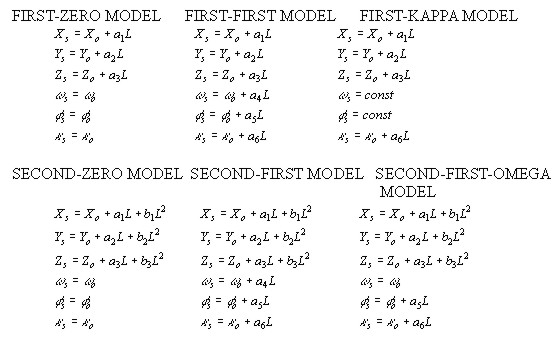
4. EXPERIMENTS AND RESULTSTo assess the behavior of each sensor model, two different stereopairs of KOMPSAT-EOC satellite images were used in the experiments. Ground control and check points were selected and measured in both stereopairs using Intergraph ImageStation. Those ground and check points for two different stereopairs are well distributed over both two stereopairs. Once ground and check points were captured, these points were surveyed by precise DGPS technique and then transformed into Korean TM coordinate system. The first stereopair depicts Nonsan area, which is shown in Figure 2. Its characteristics are listed in Table 1. The second stereo pair represents hilly and developed urban area of Pusan. The second stereopair is shown in Figure 3. Its characteristics for second stereopair are listed in Table 2.
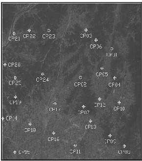
Figure 2. Nonsan stereopair (Left and Right Images) Table 1. Characteristics of Nonsan Stereopair
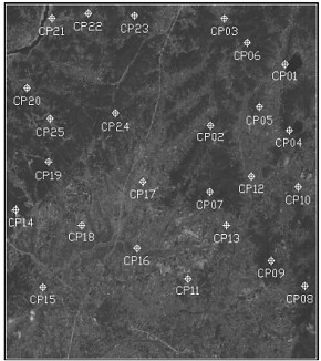
Figure 3. Pusan stereopair (Left and Right Images) Table 2. Characteristics of Pusan Stereopair
There are 17 control points and 8 check points, 18 control points and 8 check points used for Nonsan and Pusan stereospair, respectively.
Figure 4. Results of each sensor model for Nonsan images
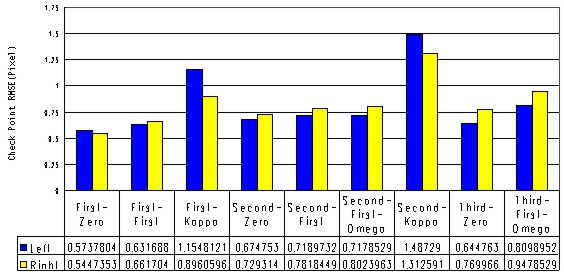
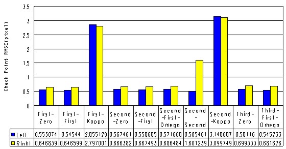
Figure 5. Results of each sensor model for Pusan images The investigation on behavior of each sensor model has been performed in two ways. First, each sensor model was applied to each KOMPSAT-EOC image. The behavior of each sensor model was analyzed with respect to RMSE of check points. Secondly, each sensor model was applied to each KOMPSAT-EOC stereopair. Again, the behavior of each sensor model was analyzed with respect to RMSE of check points. The Figure 4 and 5 show the results of each sensor model applied to each KOMPSAT-EOC image. It was found in both Nonsan and Pusan images that the FIRST-KAPPA and SECOND-KAPPA sensor model did not perform well in terms of accuracy and computing time. The other sensor models except those two models did provide the accuracy in acceptance level for capturing geospatial information.
Figure 6. Results of each sensor model for the Nonsan stereopair
Figure 7. Results of each sensor model for the Pusan stereopair The Figure 6 and 7 show the results of each sensor model applied to each KOMPSAT-EOC stereopair, which are similar to those of each sensor model to each satellite image. 5. CONCLUSIONThis paper shows the behaviors of 10 different sensor models extended from the collinearity equations applied to KOMPSAT-EOC satellite images and stereopairs, respectively. Most of sensor models except FIRST-KAPPA and SECOND-KAPPA sensor models perform provide relatively good positional accuracy. Conclusively, the FIRST-ZERO and FIRST-FIRST sensor models are stable and accurate comparing the other sensor models. The positional accuracy did fall into less than 1 pixel for both sensor models, which shows the feasibility of generating topographic maps using KOMPSAT-EOC satellite images. For cartographic purpose, the sensor model for KOMPSAT-EOC should be investigated in greater depth. In addition, the possibly identified features and feasible topographic map scale should be further studied. REFERENCES
CONTACTKiin Bang, Graduate Course Assistant Professor Woosug Cho 13 April 2001 This page is maintained by the FIG Office. Last revised on 15-03-16. |

