THE ROLE OF NON-GEODETIC PROFESSIONAL EXPERTISE OF A UNIVERSITY EDUCATED SURVEYOR IN AN EMERGING AMBIGUOUS AND UNSAFE FUTURE OF THE PROFESSIONDr Basil PSARIANOS, GreeceKey words: surveying qualifications, non-geodetic surveying. AbstractNon-geodetic activities practised around the globe are not adequately known to the surveying society. However such knowledge will help the profession overcome its current problems and redefinition of the surveyor will ensure his survival in an era of globalisation. In this paper therefore a brief description is given of the main existing non-geodetic activities associated with a surveying title, with their educational requirements and countries in which they are practised, and which are either not represented or under-represented in FIG. 1. INTRODUCTIONIn an era that is characterised worldwide by free market rules, unrestricted movement of professionals and globalisation accompanied by high qualifications and expertise requirements, professional titles and definitions have lost their original meanings and contents. This trend is quite evident in the old and traditional professions, such as medicine, law and engineering. It was quite evident for example 200 hundred years ago that a doctor was called upon to cure almost every malady by applying every known treatment at that time including all kinds surgery; and an engineer should be able to cope with a variety of technical problems extending from building houses to bridges, even ships. In modern times however traditional professional names, i.e. civil engineer, surveyor, etc. have a very abstract meaning, and speaking in market terms they are fully incomprehensible. Under professional names a large number of professional activities are understood, which are associated traditionally with a specific profession. Indeed professional names represent nowadays an umbrella-name underneath which specific activities are covered. Belonging to a profession is not nowadays sufficient for carrying out a successful career. Professions are developed in modern times on the basis of compliance to the fulfilment of the requirements of a specific job description, i.e. to be an expert in a specific field, which in turn will provide an individual with the capabilities to carry out successfully a specific job. Surveying being one of the oldest technical disciplines is no exception to this rule. But in addition to the general features that are imposed on all professions worldwide, the surveying profession is suffering from some specific and endogenous problems. 2. THE SURVEYING PROBLEMSurveying in the beginning of the 21st century is confronted with two significant challenges:
Impact of new technologies Surveying has relied from its origins on measurements (data gathering) and data interpretation, data managing and manipulation (modelling), i.e. KENNIE 1998. For centuries surveyors have been essential for correct and accurate data gathering and modelling. However technological evolutions in the last twenty years of the twentieth century have dramatically changed the data gathering and modelling process in a way that surveying qualifications are easily attained. Consequently market needs have been transferred from the BAC+3 or higher qualifications standard, to the technician level standards. This applies to both the public and the private sectors. This is clearly reflected in the declining number of students attending university surveying courses in many countries, as well as the patterns of hiring surveying personnel by technical firms and public offices. In Germany for example an increase of 11.5% of surveying technicians between the years 1984 and 1995 in the public sector has been recorded, while qualified surveying engineers have been reduced by 10.6% in the same period. This trend will continue in the years to come and it is expected that the ratio between newly qualified surveying personnel qualified to BAC+4.5 to newly qualified technicians, will for the first time be around 1:7 each year (SCHROEDER, 1998). The surveying profession itself Although all professions are undergoing development processes for various reasons, one can hardly find a technical profession that compares with the surveying profession in terms of its variation, diversification, split, and its undefined or untrained professional sectors. The FIG definition of Surveyor is by no means complete and all-inclusive. It needs to be adapted to reflect the profession's full coverage of branches and activities as practised in, and recognised or accepted by the market globally. In a world where globalisation seems to be the driving force of economical development, surveyors must depart from local and biased definitions of their professional boundaries, and be fully aware of their opportunities in a world market. A complete understanding of what surveyors are and what role they play or can play in a very competitive free world market, is a prerequisite of re-establishing an attractive professional field. Surveyors in one part of the world learning from the opportunities that surveyors from other parts of the world have developed, may help them overcome either reduction of the demanded qualification standards, or the shrinkage of professional prosperity and image experienced locally. The often expressed aim and task of the modern surveyor is to go beyond the profile of professional being solely a "data supplier" or "data administrator" (MAGEL, 1999) and achieve the profile of a professional with "integrated competence" in land, property and construction management. As envisioned by FIG (KENNIE, 1998) this demands the synergetic effort of education, professional organizations and institutions on a national and international level in the years to come. Non-geodetic surveying activities is a professional domain, where surveyors have succeeded in becoming successful professionals with high level qualifications. Standards are verified by wide acceptance at a national and international level by that most objective and final accreditation body, the free market. By doing so, non-geodetic surveyors have managed to overcome the burdens from which the profession is currently suffering. Non-geodetic surveyors have indeed "broadened the scope of our activities" in the words of the current FIG President R. W. Foster (FOSTER, 1999) and have paved the way for the successful market entry by highly qualified, highly respected surveying professionals. The area covered by non-geodetic activities is not well known even by the surveying society worldwide. Unfortunately many of the fields of the non-geodetic activities are not included and not represented within FIG itself. This is one main reason for ignoring the extension the whole surveying profession has attained in the past years. In the following an effort will be made to describe these activities to a wide extent, but with no claim of completeness. It will especially focus on surveying non-geodetic activities mostly unknown to the vast majority of the surveying society! 3. A GENERAL OVERVIEW OF NON-GEODETIC ACTIVITIES NOT REPRESENTED IN FIGNon-geodetic activities cover a wide range of activities and require a specific educational background, occasionally not provided by conventional surveying or geomatics curricula. Since qualifications are acquired frequently outside the conventional path of a geodetic surveyor, specific professional organisations or institutions other than the geodetic institutions provide accreditation or licensing for practicing such activities. Some of the non-geodetic activities of surveyors are represented within the existing commissions of FIG and therefore may be assumed to be adequately known to the surveying community, i.e. urban planning, valuation, land management, etc. In the list, that follows an effort has been made to describe in brief the most common non-geodetic activities, which are either not represented or are under-represented in FIG, including the specific educational and / or qualification requirements associated with them. Furthermore due to the variety and the number of non-geodetic activities of surveyors not represented in FIG, it is not possible to present here a complete list and description of them. Therefore the description is restricted to those non-geodetic activities that are associated with a protected or unprotected Title. It should be stressed that non-geodetic activities are carried out either under an individual profile of surveying, carrying a corresponding name, i.e. quantity surveyor, or they are supplemental qualifications acquired usually in parallel to conventional surveying qualifications from a university department, i.e. rural and surveying engineer. In this latter case these supplemental activities to a surveying professional are mentioned in the list below as "relevant studies". A. ARCHAEOLOGICAL SURVEYOR
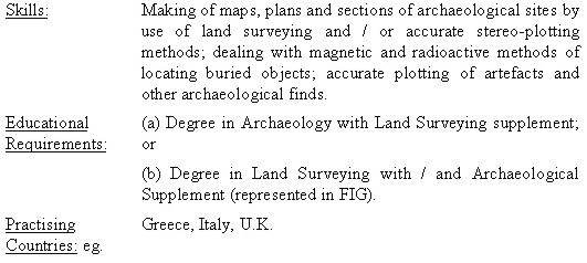
B. BUILDING SURVEYOR
C. BUILDING ENGINEERING SERVICES SURVEYOR(mostly coincidental skills with the expert known as Facility Manager in the U.S.A.)
D. CIVIL ENGINEERING SURVEYOR
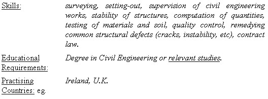
E. CONSTRUCTION SURVEYOR
F. ENVIRONMENTAL ENGINEER
G. ESTATES SURVEYOR(partially overlapping with the valuation surveyor, who is fully represented in FIG)
H. MINING SURVEYOR
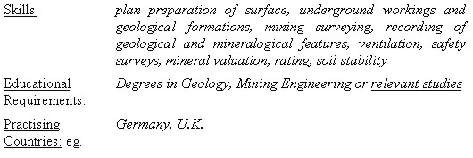
I. MUNICIPAL SURVEYOR
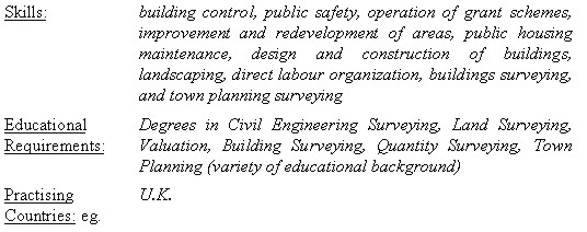
J. TOWN PLANNING SURVEYOR
K. QUANTITY SURVEYOR
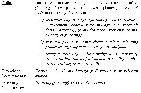
L. RURAL AND SURVEYING ENGINEER
4. CONCLUDING REMARKSFrom the presentation above it should be clear that under the term surveying a great number and variety of activities are included and understood. Since these activities are not all present in the various countries, the world community of surveying is not aware of that fact. Globalisation however makes it imperative to understand this reality, and above all to make use of it for the benefit of the profession as a whole worldwide. Such understanding and dynamic acceptance of the whole spectrum of surveying activities will help solve the endogenous problems of the profession, raise the confidence and image of the surveyors in the technical world and in society, and provide competence and competitiveness to the individual surveyor. This is in full compliance with the vision of FIG to move the profession towards the model of integrated competence as it was presented in Singapore in 1996, (KENNIE, 1998). Especially the value of planning should be underlined here. Where surveyors have become planners, they have not only secured their professional position in society and the market, but also kept unaffected the modern surveying achievements such as GIS. Because who can define, handle and implement a complex GIS for very specific planning purposes, (say for use in transportation planning, known as GIS-T), better than a surveying engineer with transportation background? The advice of R.W. Foster, current President of FIG, is clear and straightforward on the subject of identifying all surveying activities and defining a universal and global profile for surveyors:
There is no doubt that " it will not be easy". To achieve such an objective " legislation, educational systems and institutional arrangements must be addressed. Political considerations may play a role. There will be resistance both from within and from outside the profession. None the less, if "surveying" is to be a player on the world scene it must expand its activities and it must be clear in its definition of itself", (FOSTER, 1999). True words spoken on a one-way path. REFERENCESFOSTER, R.W., 1999. "21st Century Challenges for the Surveying Profession", Zeitschrift fuer Vermessungswesen, Vol. 12, Germany. KENNIE, T, 1998. "Some Current Trends in the Surveying Profession and Some Possible Scenarios", FIG-ACCO Meeting, U.S.A MAGEL, H., 1999. "Vermessungswesen vor neuen Herausforderungen-Chancen fuer den Freien Beruf?", Zeitschrift fuer Vermessungswesen, Vol. 4, Germany. SCHROEDER, W., 1998. "Zur Personalsituation im Vermessungswesen", Zeitschrift fuer Vermessungswesen, Vol. 12, Germany. CONTACTDr Basil Psarianos, Assoc. Professor 22 April 2001 This page is maintained by the FIG Office. Last revised on 15-03-16. |
