by Prof. Dato’ Dr. Nik Mohd Zain bin Hj. Nik Yusof
ABSTRACT
Land information is crucial for planning and development. The rapid pace of development in Malaysia, while bringing high growth rates also brings with it heavy burdens on land utilisation. To ensure that the high growth rates can be sustained, it is imperative that Malaysia needs an effective Land Information System to plan the utilisation of it’s land resources for development while at the same time protect the environment.
NaLIS is a Land Information Infrastructure that provides facilities to users of land information to get access to land information kept in the land related agencies. Using the Internet/Intranet web technology, NaLIS provides access to land databases for records on land parcels which are distributed at the land related agencies sites viz. the Computer Assisted Land Survey System of the Survey and Mapping Department, the Computerised Land Registration System of the Land and Mines Department, the Valuation Information System of the Valuation and Property Services Department, and the Property Assessment System of the Kuala Lumpur City Hall. Besides these land records, NaLIS also provides access to spatial data kept in Geographical Information Systems at the Agriculture Department, the Geological Survey Department, the Forest Department, the Statistics Department, the Public Works Department, the Drainage and Irrigation Department and the Town and Country and Planning Department. The functionalities provided includes, Security and Access, NaLIS Data Catalogue, NaLIS Data Explorer, NaLIS Data Viewer and Administrative Module. Information on NaLIS is now available in the NaLIS Homepage at the address http://nalis.ktpk.gov.my/.
1. INTRODUCTION
1.1 The need for an effective Land Information System to assist in planning and development of land resources in Malaysia have been felt since the early 70s when serious efforts were undertaken by the Government to develop the country through the various development programmes in the Malaysian Development Plans. Through careful planning, Malaysia has been able to develop by leaps and bounds and has become a rapidly developing country that it is today, acknowledged throughout the world. The rapid development, while contributing to the high growths enjoyed by Malaysia, have also exerted heavy pressures on land utilisation. To ensure that the rapid progress made by Malaysia is sustainable, it is imperative that there is an urgent need to establish an Infrastructure for Land Information System to effectively manage its land resources.
1.2 Many efforts have been undertaken by various Federal and State Government agencies to establish land systems to speed up the processes involved in land related activities making full use of Information Technology (IT). Spearheading this effort, The Ministry of Land and Cooperative Development (MLCD) have established computerised system for agencies under the ministry as well as the land office namely;
- The Computer Assisted Mapping System (CAMS)
- The Computer Assisted Land Survey System (CALS)
- The Fast Mapping System (FMS)
- The Computerised Land Registration System (CLRS)
- The Computerised Quit Rent System (CQRS)
1.3 Besides the MLCD, computerised systems have also been established by other Federal and State land related agencies namely;
- The Valuation Information System (VIS) of the Valuation Department
- The Property Assessment System (PAS) of the Kuala Lumpur City Hall
- The Land Use System of the Agriculture Department
- The Population Information System of the Statistics Department
- The Land and Survey Information System (LASIS) of Sarawak
- The Land and Survey Information System of Sabah
- The Penang Geographical Information System (PEGIS)
- The System for Managing and Mapping of Utilities and Infrastructures (SUTRA) of the Public Works Department
- The Forest Information System of Peninsular Malaysia Forest Department
- The Forest Information System of the Sabah Forest Department
1.4 With the establishment of these computerised systems, the stage is now set for Malaysia to make full use of IT to assist in planning and development of its land resources. These systems constitute valuable sources of land information that can be utilised for the purpose of planning development and control of land resources in Malaysia. However, currently these systems exist as stand alone systems and thereby cannot be fully utilised to provide timely information to land information users. The National infrastructure for Land Information System (NaLIS) is established in Malaysia to provide timely access to land information to users of land information.
2. BASIS OF CONSIDERATION
2.1 Data
2.1.1 Land Data is crucial to promote economic development, improve the quality of live and at the same time protect the environment. It consist of Spatial Data that refers to visual locations on the earth’s surface as well as textual data that refers to its attributes and features. The availability of these data is crucial for a critical analysis and evaluation of land for development using Geographical Information System (GIS). Collecting these data is a time consuming and costly affair, for this requires carrying out field surveys to record features on the ground and aerial photography to record the changes that take place as well as computations to represent what is on the earth’s surface at any point of time. The difficulty of collecting these data is further compounded by the fact that to assemble all the data that is necessary requires a multi disciplinary effort of many land related agencies. As such, it cannot be handled by any one single agency but by the collective effort of many land related agencies at the Federal, State and Local level.
2.1.2 Experiences of countries that have undertaken the task of a systematic collection of land data such as the USA, Canada,Sweden and Australia, shows that this can only be done by a concerted effort on the part of the Government by mobilising the activities of the land related agencies in a coordinated manner to collect all the necessary information under their respective jurisdictions. These information once collected is then shared by all the agencies concerned thereby reducing duplications and costs in its collection and maintenance.
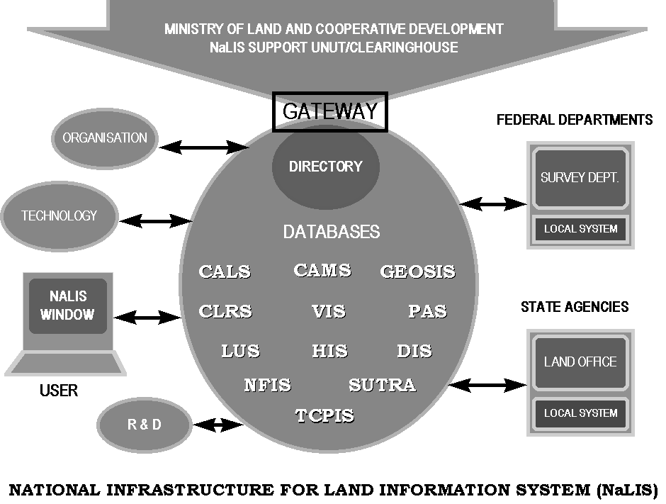
2.1.3 Likewise in Malaysia, a concerted effort of all land related agencies is required to collect land information for the purpose of managing its land resources. The existing data collection mechanisms of the land related agencies can be used to provide critical land information that is required for land use planning and control of land resources. This approach is far more practical as the success of NaLIS depends on the availability of timely information on land. The land related agencies, being responsible for the land data under their respective jurisdictions, provide the best mechanism to ensure the availability of land information. By providing the infrastructure for users of land information to get access to data that exist in the systems of the land related agencies, users of land information do not have to establish data collection mechanisms of their own to get the data that they need. The single window facility provided under NaLIS as shown in Figure 1 will enable users of land information to obtain data from all the land related agencies that contribute data to the system no matter where they are located. This will save time and money for users of land information to get the information that they need.
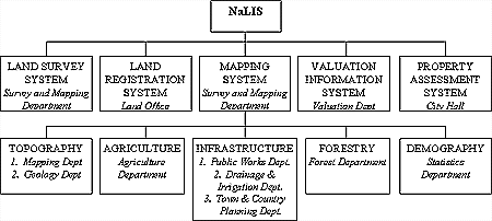
2.1.4 The information that can be made available to land information users under NaLIS consists of datasets taken from databases of the agencies linked to NaLIS as shown in the Figure 2.These constitute data that the land related agencies keep in their respective systems for their business operations namely;
- The Survey and Mapping Department for land surveys and mapping
- The Land Office for land ownership and dealings
- The Valuation and Property Services Department for land valuation
- The Land and Survey Department (Sabah and Sarawak) for i, ii, and iii above
- The Local Authorities for property assesment and building regulations
- The Agriculture Department for agricultural land use regulations
- The Geology Department for geological surveys
- The Drainage and Irrigation Department for water resources management
- The Forestry Department for forest management
- The Public Works Department for infrastructures management
- The Statistics Department for population census

Figure 1: NaLIS Single Window Access to Land Information
LAND SYSTEMS LINKED TO NaLIS

Figure 2: Land Systems Linked to NaLIS
2.1.5 These data sets are abstracts of the data replicated from the databases of the land related agencies that can be made available to land information users on request in an on-line real-time system through NaLIS. However land data being very sensitive in nature, requires extra precautionary measures to prevent unauthorised access. Many agencies that keep these data expressed concerns on data security if access to these sensitive and critical land data is allowed to outside users. Hence there is a need to institute a very tight security control to get access to data in NaLIS to prevent land information getting into the wrong hands.
2.1.6 To protect the interest of the owners of data, NaLIS provides the facility for the sharing of data for the purpose of planning development and control of land resources subject to the following conditions.
- Data ownership remains with the respective agencies
- Use of data is subject to conditions set by the owners of the data
- The NaLIS Clearinghouse acts only to facilitate the sharing of data
2.2 Technology
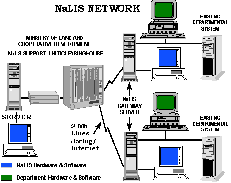
2.2.1 Currently the data that is kept by the land related agencies exist in different computer systems. As such to enable users to share and use the data from different computer systems, data interfaces/standards that will enable data to be communicated between different computer systems is provided. With the interfacing and networking facilities provided under NaLIS, users can brouse through the data directory and data dictionary to select and request the information that they need from the various computer systems of the land related agencies. The technology that is required for NaLIS includes hardware, software, networking and communication facilities made available at the land related agencies that are data providers as well as at the data user agencies under NaLIS network as shown in Figure 3.
2.2.2 To provide the technology required for NaLIS, it is necessary that;
a) NaLIS is built on an open system platform that can evolve to meet the requirements of users and the available technology. This means that it can adapt to the latest technologies as and when they are made available. This is to ensure that users can continue to use their existing systems without having to migrate to another system to ensure that the data, being the most valuable asset that exist in their systems, can continue to be used while taking advantages of the latest technologies that is made available.
"The development of computer and Information Technology is taking over many manual tasks and in spite of the high initial costs of capital outlay, can offer significant reduction in cost. The most expensive and time consuming part of LIS is the collection of data. A trend towards decentralisation and deconcentration, with smaller dedicated systems linked together to form a larger system is seen. To provide the linkage, standards for interchange of data must be established and a common spatial referencing system enforced. Effective co-operation and co-ordination among agencies is essential".

Figure 3: NaLIS Network
2.3 Organisation
2.3.1 NaLIS involves many agencies at the Federal, State and Local level. As such its organisation would have to address the problems of coordinating the activities of the various agencies involved. The organisational set up for NaLIS, takes into consideration the existing administrative machinery as shown in Figure 4.
2.3.2 The main agencies that keep land information based on land parcels are the Survey and Mapping Department, The Land Office, The Valuation and Property Services Department and the Local Authorities. In Peninsular Malaysia, the Land Office and the Local Authorities are under the jurisdiction of the State Governments while the Survey and Mapping Department is under the Ministry of Land and Cooperative Development and the Valuation and Property Services Department is under the Ministry of Finance. In Sabah and Sarawak, land, survey and valuation activities are carried out by the Land and Survey Department under the State Government. The Local Authorities in Sabah and Sarawak are also under the jurisdiction of the State Government. Each of these departments handles land matters under their respective jurisdictions which is defined by geographical areas of coverage.
Figure 4: NaLIS Organisation
2.3.3 The Chief Secretary to the Government as head of the public service has issued the Public Administration Development Circular No. 1 1997 providing guidelines to the Secretary Generals of Ministries, Heads of Federal Departments, Heads of Statutory Bodies, State Secretaries and Heads of Local Authorities on the Establishment of the National Infrastructure for Land Information System dated 2 January 1997 with the following provisions:-
- At the National Level a NaLIS Coordinating Committee (NCC) is formed to coordinate the production and and utilisation of critical land infromation needed for the purpose of planning and development of land resources.
- At the State level a State NaLIS Coordinating Committee is formed to coordinate NaLIS activities carried out by the state agencies.
- The Department of Survey and Mapping Malaysia provides the secretariate for NaLIS.
2.3.4 The Development of the NaLIS Clearinghouse is provided for in sections 13-17 of the circular as shown in Appendix 1.
3. NaLIS Prototype
3.1 The NaLIS Prototype is being developed for the Wilayah Persekutuan Kuala Lumpur and the State of Pulau Pinang with the following objectives.
- To develop and implement the initial NaLIS Prototype using an Internet/Intranet architecture.
- To propose subsequent phase to the prototype, for application by the LRA’s in the NaLIS Community.
- To facilitate the transfer of technology and skill development to the NaLIS Technical Team.
3.2 Using the National Spatial Data Infrastructure of the United States as a model, the NaLIS Prototype will provide the facilities for user acess to land data residing at the data providers sites. The functionalities to be provided in the prototype includes;
- Security and Access
- NaLIS Data Catelogue
- NaLIS Data Explorer
- NaLIS Data Viewer and
- Administrative module
3.3 The organisation for the development of the NaLIS Prototype involves the Ministry of Land and Cooperative Development (MLCD), the NaLIS Technical Committee (NTC), Oracle Systems Malaysia, ESRI South Asia, ERSIS Asia, Digital Equipment Malaysia and other vendors shown in Figure 5.
Figure 5: NaLIS Prototype Development Organisation
3.4 Detail user requirements and system studies have been completed. Information on NaLIS is now available in the NaLIS Homepage in the Internet at the address http://nalis.ktpk.gov.my/. The NaLIS Homepage also provides links to other Land Information Infrastructure projects currently undertaken around the world.
4 Funding of NaLIS
4.1 The main data providers to NaLIS are the Land Office and the Survey and Mapping Department in the case of Peninsular Malaysia and the Land and Survey Department in the case of Sabah and Sarawak. In the deliberations of the NaLIS task Force with the relevant authorities of the various states, objections were raised on the possibility of privatising the activities of these departments. The states have indicated that they will not participate in NaLIS if the project is to be privatised. The main reason for this objection is that these departments perform legal functions and as such they are instruments of government. This is in line with the practice followed by all countries whereby land matters are handled by government departments.
4.2 The Swedish Land Data Bank System is operated by the Central Board for Real Estate Data which is a government department fully funded by the government. The same is true with the National Spatial Data Infrastructure of the United States of America which is operated by the Federal Administration. The USA Administration spends three billion US dollars annually to make spatial data available. The BC-On Line System of British Columbia Canada is also operated by the Government of British Columbia. The Land Data Hub of Singapore is operated by the Minister of Law. Services in land data in Australia, United Kingdom and in Europe are also provided by the government. The administration of land matters is the basic duty of government that cannot be entrusted to private individuals.
4.3 Likewise, the cost of NaLIS in Malaysia is borne by the Government whereby;
- The Federal Government provides the funding for the NaLIS infrastructures which includes the hardwares, softwares and networking facilities as well as the cost for its development and maintenance.
- The cost of the production of data is born by the respective land related agencies participating in NaLIS.
- The cost of the NaLIS Prototype is fully borne by the Federal Government.
- To ensure proper coordination and to avoid duplications, all government agencies shall seek the approval of the NCC before it expends government funds to collect or produce land data.
5. CONCLUSION
NaLIS is a practical approach to solve the problems currently faced to get timely information on land. By providing the necessary infructures under NaLIS the mechanisms thereby established can ensure that the much needed land information could be made available to users on-line real-time making full use of Information Technology. The establishment of NaLIS also ties in with the efforts currently undertaken to establish the Government Integrated Telecommunication Network (GITN) and the Multimedia Super Corridor (MSC) in Malaysia. GITN and MSC provides the Information Superhighway while NaLIS provides the content. With the establishment of these systems, the nation is well placed to meet the objectives of Vision 2020 for Malaysia to be an information rich networking society to meet the challenges of the digital economy of the 21st century.
EPILOGUE
The Ministry of Land and Cooperative Development thanks the following organisations for assistance given in formulating the strategies for the establishment of NaLIS in Malaysia.