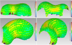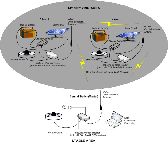
The combination of different sensors in static (e.g. monitoring) and dynamic (e.g. kinematic data acquisition) environments is a typical task in engineering geodesy and surveying. This covers sensors combined in one instrument (e.g. in terrestrial laser scanners or total stations) as well as measurement systems combing different sensors or instruments for integrated solutions (e.g. Static GNSS Monitoring Arrays or Mobile Mapping).
The complexity of multi-sensor systems has to take into account a variety of random and systematic influences. There is an obvious need for new sensor models and calibration procedures to reduce or even eliminate errors and influences. Typical uncertainty modelling approaches are variance-covariance propagation, Monte Carlo simulation, Bayesian statistics, Fuzzy approaches or interval mathematics. In addition, quality characteristics as correctness, reliability, completeness, robustness, integrity or availability may play a role. These may be seen as stand-alone quality aspects or as parts of a complete quality model.
 |
Theoretical and numerical developments as well as state-of-the-art best-practise examples (monitoring surveys: GNSS and total stations, terrestrial laser scanning, point-wise and area-wise monitoring, kinematic positioning, sensor fusion, mobile mapping) may be presented at the workshop. The workshop addresses all colleagues active in research and development of multi-sensor systems, but also practitioners who are willing to get newest information on the described research domain. |
The workshop will live from your contributions resulting from this call-for-papers dedicated to the above mentioned topics and integrated into the call-for-papers of FIG Congress. Invited speakers will supplement it.

SESSION 1: QUALITY AND UNCERTAINTY
Chair: Prof. Heiner Kuhlmann, Germany
Volker Schwieger (Germany):
Quality in Engineering Geodesy - an Introduction to the Topic and to the Workshop (11779)
[abstract] [paper] [handouts] [video]
Qingquan Li, Jiasong Zhu, Dejin Zhang, Wei Tu, Chisheng Wang, Zhipeng Chen and Siting Xiong (China, PR):
Dynamic and Precise Surveying for Water Resource Engineering —Dams, Bridges and Pipelines (11772)
[abstract] [paper] [handouts] [video]
SESSION 2: ALGORITHMS FOR KINEMATIC POSITIONING
Chair: Mr. Xiong Si-Ting, China
Gereon Tombrink, Ansgar Dreier, Lasse Klingbeil and Heiner Kuhlmann (Germany):
Trajectory Evaluation Using Repeated Rail-Bound Measurements (11333)
[abstract] [paper] [handouts] [video]
Gilles Teodori and Hans Neuner (Austria):
Investigation of the Inherent Trade-Off Between Bias Model Complexity and State Estimation Accuracy in INS-GNSS-Integration (11608)
[abstract] [paper] [handouts] [video]
SESSION 3: QUALITY OF TERRESTRIAL LASER SCANNING
Chair: Eng. Maria Joao Henriques, Chair FIG Commission 6, Portugal
Jan Hartmann and Ingo Neumann (Germany):
Automatic and Efficient Quality Assessment of Terrestrial Laser Scans (11443)
[abstract] [paper] [handouts] [video]
Derek D Lichti (Canada):
Closed-Form Modelling of Vertical Cylinder Quality in Support of Laser Scanner Network Design (11650)
[abstract] [paper] [handouts] [video]
Gabriel Kerekes and Volker Schwieger (Germany):
Object Surface Properties in TLS Measurements: an Approach Based on the Elementary Error Theory (11380)
[abstract] [paper] [handouts] [video]
SESSION 4: QUALITY OF TERRESTRIAL LASER SCANNING,
MONITORING NETWORKS
Chair: Mr. Ireneusz Wyczalek, Poland
Andreas Ullrich and Nikolaus Studnicka (Austria):
Survey-Grade Lidar Systems Utilizing Sensor Fusion for Static and Kinematic Lidar Data Acquisition (11749)
[abstract] [paper] [handouts] [video]
Werner Lienhart (Austria):
Uncertainty Assessment of High Frequent Laser Distance and Strain Measurements (11778)
[abstract] [paper] [handouts] [video]
Krzysztof Karsznia (Poland) and Leonardo Lia (Italy):
Functional and Accuracy Assessment of a Multisensorial Deformation Monitoring System Implemented for the Development Purposes of Warsaw Metro Line Ii (11478)
[abstract] [paper] [handouts] [video]
Selected presentations may be published after a peer-review process within the Journal of Applied Geodesy. The deadline will be 1st September 2022.
Organisers: FIG Commission 6 Engineering Surveying & German Geodetic Commission, Department of Engineering Geodesy
| Pre-event Sponsor |
 |
|